AOSN-II August 2003
The ESSE forecast for August 27, 0000 GMT was initialized from an error nowcast for August 26, 0000 GMT. The background ocean field on August 26, 0000 GMT is a HOPS forecast simulation which assimilates all available and calibrated data up to August 25, 10GMT (several R/V Pt Sur and gliders profiles being processed for Aug22-25 were not utilized).
The dominant 275 eigenvectors of the posterior error covariance estimate for August 26, 0000 GMT were utilized to perturb the ocean fields on August 26, 0000 GMT. A white noise of an amplitude proportional to the estimated absolute and relative errors in the observations is added to this random combination, in part to represent the errors truncated by the error subspace. An ensemble of 1-day forecast simulations, each forced by forecast COAMPS atmospheric fluxes issued for Aug 25, was then carried out.
A total of 450 ensemble 1-day forecasts were carried out during the night of Aug 25 (EST). The corresponding error standard deviation forecast for August 27, 000GMT are shown in the table below.
| Full Domain | |||
| Temperature | Salinity | U velocity component | V velocity component |
| Monterey Bay Zoom | |||
| Temperature | Salinity | U velocity component | V velocity component |
| Barotropic Streamfunction (including Monterey Bay) | |||
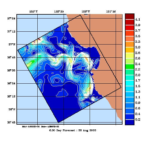
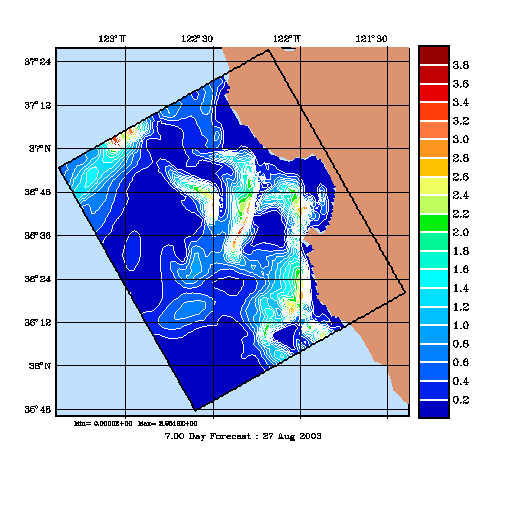
The ESSE uncertainty forecasts are a function of: the posterior (initial condition) uncertainties, the dynamical evolution of these initial uncertainties, the impacts of model error estimates which are compounded during this evolution and the COAMPS forcings. One of this process, the dynamical evolution of uncertainties, is strongly dependent on the local properties of the kinetic energy, potential energy and enstrophy (square of vorticity) fields. To partially illustrate this, the surface kinetic energy nowcast on Aug 26 and 1-day forecast on Aug 27 are given here.
Dynamics and uncertainties. In Monterey Bay, the ocean forecast still indicates the start of the re-establishment of a cyclonic circulation, mainly in response to upwelling favorable atmospheric forcings. The amplitudes of these winds are variable and often weak along the coast, which prevents a full upwelling state to develop.
For the Monterey Bay zoom, the most interesting uncertainty features relate to the structure of the coastal current across the mouth of Monterey Bay. Either a warm and fresh meander of the coastal current impinges the shelfbreak right in front of Monterey, or an upper-layer anticyclonic eddy (also warm and fresh) has pinched off from the coastal current and is interacting with the coastal current offshore and local steep topography inshore. These features are advected and mixed southward by the mean coastal current.
The strength, position, shape and interactions of the meander and/or meander-anticyclone are uncertain. They lead to large expected standard deviations in T and S, in surface near the center of the mouth of the Bay and at depth (e.g. 30m) just offshore of the Monterey Bay Peninsula (where the coastal current meanders at these depths). The corresponding cross-slope (U) velocity uncertainties are largest in surface near the center of the mouth of Bay, while the along-slope (V) velocity are largest along the whole mouth of the Bay (edge of the Monterey Bay zoom domain in the Table above). The barotropic stream function errors remain the largest west of the Peninsula above the deepest/steepest bathymetry. These velocity uncertainties agree with the forecast dynamics of the coastal current and anticylone.
In the center of Monterey Bay, some uncertainties are also present, in relation with the strength and position of the re-establishing cyclonic circulation.
For the full domain, uncertainties remain large along the meanders of the coastal current. The upper-layer eddy field (10-40m depth) which feeds on the available energy in the surface thermocline also has a strong influence on the error field (e.g. see eddy hot-spots at 30m). Corresponding properties can be seen in the velocity and transport error standard deviations. Uncertainties are also high just west and south of Pt Sur (southern domain), along the edges of the upwelling front. Uncertainties are also in general higher on the southern part of the domain due to the lack of data in the region. Finally, the effect of the boundary condition error growth starts to be visible.
Computations. The software for the automated management of the parallel perturbation and distribution of the ensemble of forecasts was improved. Using a set of 5 Sun-workstations (which amount to a total of 15 to 20 CPUs available on average), the improved management reduced the elapsed computational time by a factor 2.