Assessment of Skill for Coastal Ocean Transients
ASCOT-02
Tyrrhenian Sea/Ligurian Sea/Elba/Procchio Bay
May 2002
An Experiment for Ocean Coastal Prediction and
NATO Rapid Environmental Assessment Skills Evaluation
A.R. Robinson, W. G. Leslie, R. Onken, P.J. Haley, Jr.

NATO SACLANT Undersea Research Centre

Harvard University
January 2002
Table of Contents
1. Introduction
2. Goals and Objectives
3. Geographic and Oceanographic Context
4. Forecast Methodology
5. Nested Modeling Domains
6. Schedule and Sample Tracks
7. Adaptive Sampling
8. Distributed Systems and Logistics
Sections of the document pertaining to operations are highlighted above in red.
1. Introduction
Coastal Predictive Skill Experimentation (CPSE) measures the ability of a forecast system to combine model results and observations in coastal domains or regimes and to accurately define the present state and predict the future state. Rapid Environmental Assessment (REA) is defined in the military environment as "the acquisition, compilation and release of tactically relevant environmental information in a tactically relevant time frame". Ocean forecasting is essential for effective and efficient REA operations. A REA CPSE must be designed to determine forecast skill on the basis of minimal and covertly attainable observations and thus may be most efficiently carried out in the context of the definitive over-sampling provided by a CPSE.
Environmental observations are a necessity for initialization and updating of ocean forecasts. Numerical ocean forecast capabilities in general consist of observational networks, data assimilation schemes and dynamic forecast models. Since observations are the most expensive part of the forecast and are often difficult to achieve, methods that would reduce the requirements are highly desirable. Knowledge of features, structures and the dynamics which evolves them is necessary for successful forecasting. Adaptive sampling of the observations of greatest impact increases efficiency and can drastically reduce the observational requirements, i.e. by one or two orders of magnitude. This project will develop methodology for ocean forecasting using minimum input.
The Assessment of Skill for Coastal Ocean Transients (ASCOT) project is a series of real-time CPSE/REA experiments and simulations focused on quantitative skill evaluation and cost-effective forecast system development. ASCOT-01, carried out in Massachusetts Bay/Gulf of Maine in June 2001, was the first such experiment. ASCOT-02 is planned for the Eastern Ligurian Sea in May 2002.
2. Goals and Objectives
ASCOT Overall Goal: to enhance the efficiency, improve the accuracy and extend the scope of nowcasting and forecasting of oceanic fields for Coastal Predictive Skill Experimentation and for Rapid Environmental Assessment in the coastal ocean and to quantify such CPSE and REA capabilities.
ASCOT General Objectives:
obtain data sets adequate for: 1) definitive real-time verification of regional coastal ocean predictive skills, with and without REA constraints; 2) CPSE and REA Observational System Simulation Experiments (OSSEs), both for ASCOT design and more generally; and, 3) definitive knowledge of dynamics
define useful skill metrics and real-time forecast validation and verification procedures for REA
assemble, calibrate, exercise in real-time, evaluate and improve a generic, portable, scalable advanced ocean forecast system (dynamical models and data analysis, management and assimilation schemes) applicable for CPSE in general and NATO REA in particular.
ASCOT-02 Objectives:
carry out and quantitatively evaluate in the Eastern Ligurian Sea in the region of the island of Elba a multiscale real-time forecast experiment
obtain a data set adequate to define coupled dynamical processes (submeso-, meso-, bay-, gulf- scales) that govern the formation and evolution of structures and events, including generic processes and the coupling of wind-forced events and buoyancy currents
obtain an intensive data set adequate for definitive quantitative skill assessment and suitable for the design of minimal data requirements for both REA and for an efficient regional monitoring and prediction system
support AUV exercises
provide a rigorous real time test of a distributed ocean prediction system technology.
REA requires multiscale capabilities for different kinds of warfare (e.g. anti-submarine (ASW), mine warfare (MW), etc.). An experiment which is to assess the predictive skill of a forecast system must therefore measure and evaluate on multiple scales. Knowledge of the multiscale dynamics is essential. Skill metrics will be designed to take the coupling of scales into account. All coastal regions require both generic and regional-specific metrics for the dominant variabilities. For example, upwelling is a generic process, however, the location and time of occurrence of upwelling is specific to the region.
As a predictive skill experiment, ASCOT-02 will include oversampling, in order that sources of error can be tracked. During the verification survey a significant fraction of the initialization survey will be repeated. Specific goals of the adaptive sampling will include: specification of the sampling patterns for the AUVs; sampling in regions not yet covered to locate local structures; sampling in regions not recently covered to understand the evolution of structures; sampling to determine the strength and structure of the anticyclone north of Elba; sampling to determine the general nature of the flow in vicinity of Procchio Bay (e.g.. is it from the north or the result of flow through the Corsican Channel from the Tyrrhenian turning around the island?); sampling to evaluate the structure and evolution of the flow between Corsica and Elba; sampling to determine the impact of the flow between Elba and the coast of Italy; and, sampling to determine the nature of conditions in Procchio Bay; coupling of wind-response and buoyancy currents; and, reduction of multi-variate forecast errors.
3. Geographic and Oceanographic Context
The island of Elba lies off the western coast of Italy in the Corsican Channel, which connects the Ligurian Sea to the north with the Tyrrhenian Sea to the south (Figure 1). The dominant large scale general circulation features of these two seas in late September 2000 are indicated in the sea surface temperature of the figure as an elongated cool pool of water (Ligurian Sea cyclonic gyre) and a pair of cool (cyclonic) and warm (anti-cyclonic) gyres in the Tyrrhenian. The circulation and variabilities of the Corsican Channel are driven interactively by the circulation and variabilities of the south-eastern Ligurian and northern Tyrrhenian, as well as by direct local atmospheric fluxes. Bonifazio Strait, between the islands of Corsica and Sardinia, is famous for strong wind (Moen, 1984). Also, directly east of the strait, westerly wind is stronger than in the shadow of the islands. An area of enhanced turbulence is reflected by lower temperatures. The prevailing westerly wind through the strait induces a pair of eddies in the northern Tyrrhenian Sea (Artale et al., 1994). The cyclonic eddy in the north lifts up the thermocline with the consequence of a cool surface signature (e.g. Philippe and Harang, 1982). On both sides of Corsica currents are directed to the north (Astraldi et al., 1990; Vignudelli et al., 1999). North of Corsica, the combined flow sets along the Riviera coast, thus closing the loop for the Ligurian Sea cyclone (Krivosheva, 1983). The Harvard Ocean Prediction System will be used to carry out real time ocean forecasts for the Corsican Channel with a focus on the Gulf of Procchio, an embayment of approximately 2km x 4km located along the northern coast of the island of Elba. This section needs possible updating for May conditions.
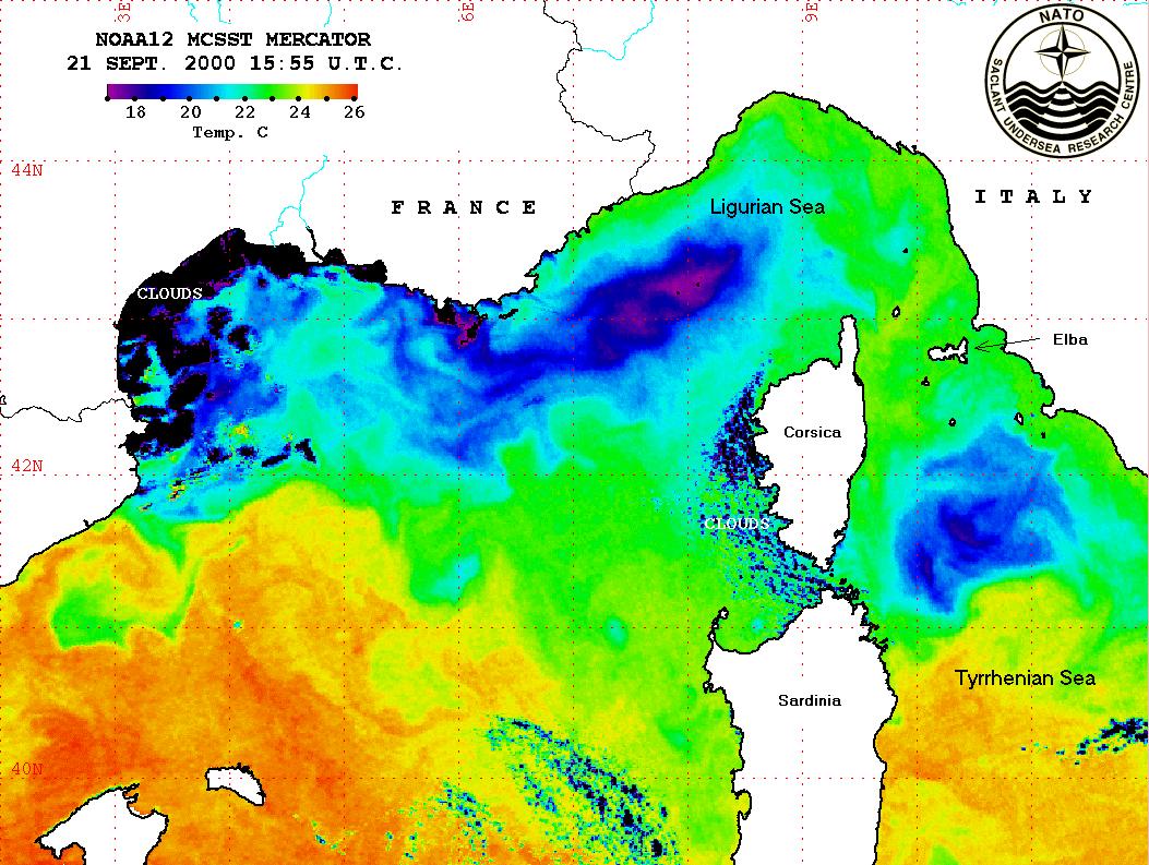
Fig. 1 - Satellite sea surface temperature in the Ligurian-Provencal Basin and the Tyrrhenian Sea during September 2000.
4. Forecast Methodology
The Harvard Ocean Prediction System (HOPS, Figure 2) consists of data analysis and assimilation schemes, and a suite of coupled interdisciplinary (physical, acoustical, optical, biogeochemical-ecosystem) dynamical models (Robinson et al., 1998; Robinson, 1999; Robinson and Glenn, 1999). HOPS employs a primitive equation (PE) physical dynamical circulation model. Boundary layers (top and bottom) and isopycnal and diapycnal turbulence are modeled through process parameterization, turbulence closure schemes, or scale-dependent filters. Multiple sigma vertical coordinates are calibrated for accurate modelling of steep topography. Multiple two-way nests are an existing option for the horizontal grids. HOPS is used to build and maintain a regional synoptic description through nowcasting, forecasting and assimilation.
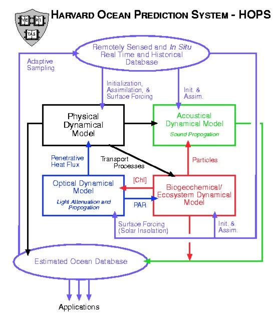
Fig. 2 - Harvard Ocean Prediction System (HOPS).
Each working day, data will be analyzed and gridded into fields, model runs performed, adaptive sampling plans designed and disseminated, and nowcasts and forecasts issued via the GOATS web site. The HOPS modelling is performed under the guideline: "assimilate yesterday's data today for tomorrow's forecast". In other words, each morning, data collected during the previous day and night was available to be processed and analyzed. The data is utilized in model runs that produced nowcasts and forecasts to be issued the next day. The HOPS model system will be run at Harvard University on a set of Sun Ultra-80 quad-processor workstations.
5. Nested Modeling Domains
The design of the modelling domains was accomplished by first reviewing the dynamical processes in the region and examining the topographic influences on these processes. These issues are balanced against the computational resources required for the simulations. The model system was tuned by investigating objective analysis (OA) parameters in local (such as around Elba) and far-field (in the Ligurian Sea) regions, temporal correlation parameters, various dynamical model parameters, assimilation criteria, vertical resolution, assimilation methodologies, etc, through a series of OSSEs. The domains were further refined based on these results and the sensitivity studies redone until a robust oceanographic observation and prediction system emerged. The model tuning was validated by comparing model output fields with objective analysis maps of data, AVHRR imagery, and documented circulation patterns in the region.
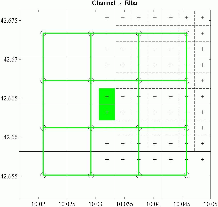
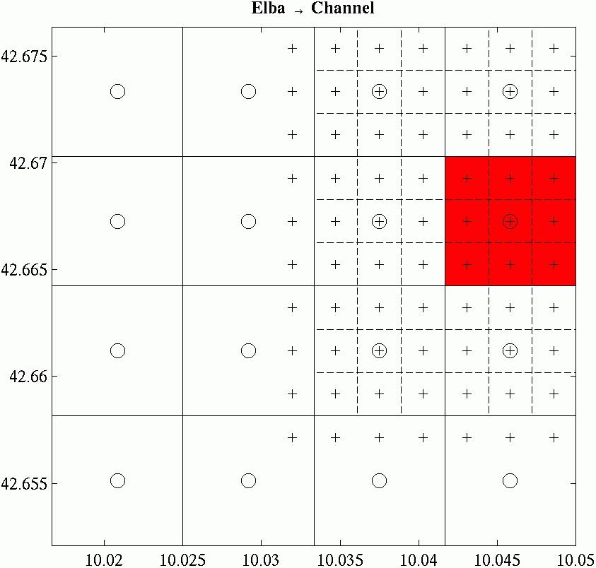
A two-way nested domain pair consists of a dynamical model defined in two domains, one with coarser resolution containing the other with finer resolution. Information from the finer resolution domain is used to replace information in the coarser resolution domain areas which intersects with the finer resolution domain (up-scale). Information from the coarser resolution domain around the boundaries of the finer resolution domain is interpolated to improve boundary information in the finer resolution domain (down-scale).
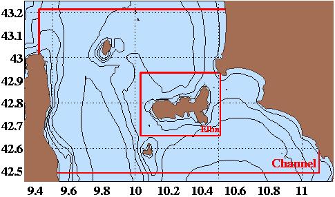
Fig. 3 - Schematic of the HOPS operational nested modelling domains.
The operational nested modelling domains for real-time nowcasting and forecasting are known as the "Channel" and "Elba" domains. These HOPS domains are pictured in Figure 3. Figure 4 depicts the process of the two-way nesting. At each time step, independent estimates are made in each domain. The left-hand panel indicates how the coarse grid (green circles) is interpolated using bi-cubic interpolation onto the fine grid boundaries (green highlighted plus signs). The right-hand panel demonstrates how the fine grid data (red highlighted plus signs) is averaged onto a coarse grid node (circle at the center of the red square). Collocation of the two grids simplifies navigation between the coarse nodes and supporting fine grid nodes. A 3:1 horizontal resolution ratio is used for scale matching. The domains to be used continue to be refined. Extension of the Channel Domain to the south and the Elba Domain to the east is being explored. Considerations include model run time and computational resources.
|
|
Fig. 4 - 2-way nesting for modelling domains. (left) Channel to Elba (coarse to fine), (right) Elba to Channel (fine to coarse).
Modeling Domains
|
DOMAIN |
DESCRIPTION/ SPECIFICATION |
|
Channel |
Resolution: 675m Size: 203x120x20 (nx x ny x nz) Domain center: 42.85N, 10.26E Extent: 136x80km |
|
Elba |
Resolution: 225m Size: 173x138x20 (nx x ny x nz) Domain center: 42.80N, 10.27E Extent: 39x31km |
Products will be issued for the entire "Channel" domain and for a sub-region of the "Elba" domain that included only the area of Procchio Bay. This Procchio Bay product focuses on the AUV area of interest and operations. The standard suite of GOATS/MEANS products includes:
A description of the forecast products
A discussion of the current model forcing (e.g., winds, oceanographic features) and the analysis/forecast fields
Comments on forecast methodology
Synoptic (nowcast) maps for:
Temperature (surface and 50m)
Salinity (surface and 50m)
Current speed (sub-tidal velocity vectors at the surface and 50m)
Twenty-four (24) and 48-hour forecast maps for:
Temperature (surface and 50m)
Salinity (surface and 50m)
Current speed (sub-tidal velocity vectors at the surface and 50m)
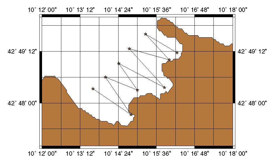
6. Schedule and Sample Tracks
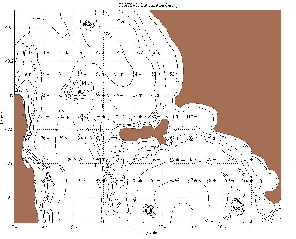
Fig. 5 - CTD stations collected during GOATS-00. A similar set of stations will be collected during ASCOT-02.
7. Adaptive Sampling
Uniformly sampled observations are generally utilized for initialization and assimilation as forecasts advance in time. Sampled uniformly over a predetermined space-time grid, these observations are usually adequate to resolve most scales of interest. However, only a small subset of the observations has a significant impact on the accuracy of the forecasts. The impact subset is related to intermittent energetic synoptic dynamical events. Adaptively sampled observations are preferable for initialization and assimilation as forecasts advance in time. The sampling scheme is tailored to the ocean state to be observed based on knowledge of the ocean state from ongoing observations, nowcasts and forecasts. Adaptive sampling targets observations that will have the greatest impact on knowledge, resolve scales of interest, and improve forecast accuracy. Efficient adaptive sampling can reduce observational requirements by one or two orders of magnitude (Robinson and Glenn, 1999).
Adaptive sampling schemes can be either subjective, objective or a combination of both. Sampling can be based on environmental forecasts or error forecasts. Forecast information is combined with a priori experience to intuitively choose future sampling. Objectively, the forecast serves as input to a quantitative sampling criterion whose optimization predicts the adapted sampling. A goal is automated objective adaptive sampling.
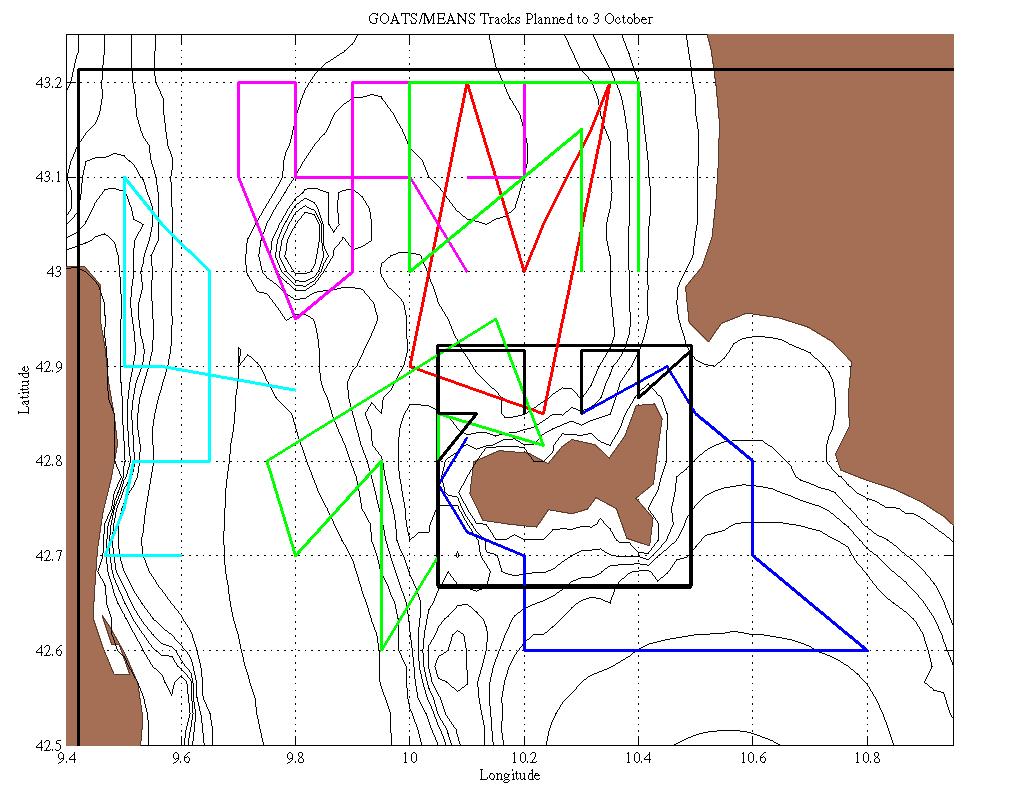
The adaptive sampling patterns in Figure 6 were designed on a nearly-daily basis during GOATS-00 and sent to the NRV Alliance. Patterns were designed both for large scale adaptive sampling carried out by the Alliance and for the AUV sampling in Procchio Bay. The efficacy of the distributed system is illustrated by the fact that scientists local to the sampling area and on board the vessels performing the sampling requested adaptive sampling patterns from scientists located thousands of kilometers away who were performing the detailed studies of the fields and their evolution.
|
|
Fig. 6 - Adaptive sampling tracks designed on a real-time basis during GOATS-00. a) for the Channel Domain; b) for the AUV in Procchio Bay.
8. Distributed Systems and Logistics
A distributed system relying on the Internet and satellite communication between NRV Alliance and SACLANTCEN was established (Robinson and Sellschopp, 2001) for GOATS-00. A similar distributed system is anticipated for ASCOT-02. Processing of the measured ocean profiles was collocated with data acquisition on board. A dial-up satellite connection with a computer at SACLANTCEN was used to send and receive electronic mail and to store processed data on an Internet server, from where exercise participants would download. The server examines the authorisation of connecting computers and persons, before it provides access to its contents.
The ship data were acquired during the night and after processing transferred to shore before noon. The time difference between Europe and New England allowed the modelling team to find the data on the server early in the morning for assimilation into the model run. Model results were required by early afternoon in order to arrive on Alliance in the evening together with a suggested station plan for sampling during night. Graphical representations of the model output were incorporated into pages with the pertinent documentation and uploaded to the server at SACLANTCEN for access by trials participants. Table 1 shows the daily time-table for the time critical activities on Alliance and at Harvard. It is expected that a similar process will be followed for ASCOT-02.
Table 1
|
Elba time |
Activity |
Boston time |
|
11:00 |
Transmit data of the night survey |
05:00 |
|
|
Final editing of input data |
06:00 |
|
|
Process data received overnight |
09:00 |
|
|
Plot and analyze completed forecast |
10:00 |
|
|
Grid data, prepare for assimilation into HOPS run |
10:00 |
|
|
Begin HOPS run |
11:00 |
|
|
Plan adaptive sampling tracks |
12:00 |
|
19:00 |
Transmit forecast and sampling plan |
13:00 |
|
20:00 |
Start CTD survey on Alliance |
|
|
|
Apply CUPOM boundary conditions |
16:00 |
|
|
Continue HOPS forecast to completion |
17:00 |
|
00:00 |
Replace CTD by XCTD and XBT |
|
|
04:00 |
Continue with CTD |
|
|
08:00 |
Survey ends close to Elba |
|
|
08:00 |
Process data of last night |
|
|
11:00 |
Transmit data of the survey |
05:00 |
Contact Information
Personnel and tasks to be updated following the January 2002 meeting.
|
Prof. Allan R. Robinson |
robinson@pacific.deas.harvard.edu
|
617-495-2819 (Office) 617-267-4359 (Home) 617-512-6437 (Cell) |
|
Wayne Leslie |
617-495-4569 (Office) 781-665-5170 (Home) 617-495-5192 (Fax) 781-718-1856 (Cell) |
|
|
Pat Haley |
617-495-2827 (Office) |
|
|
Pierre Lermusiaux |
617-495-0378 (Office) |
|
|
Oleg Logoutov |
617-496-4939 (Office) |
|
|
Patricia Moreno |
617-495-8051 (Office) |
|
|
Gioia Sweetland |
617-495-2919 (Office) |
References
Artale, V., Astraldi, M., Buffoni, G. and Gasparini, G.P., 1994. Seasonal variability of the gyre-scale circulation in the northern Tyrrhenian Sea, J. Geophys. Res., 99, 14,127-14,137.
Astraldi, M., Gasparini, G.P. and Manzella, G.M.R., 1990. Temporal variability of currents in the eastern Ligurian Sea, J. Geophys. Res., 95, 1515-1522.
Bovio, E. and Schmidt, H. (editors), 2001. GOATS 2000, SACLANTCEN Conference Proceedings Series CP-46.
Clifford, M., Horton, C. and Schmitz, J., 1994. SWAFS: Shallow Water Analysis and Forecast System, IEEE Oceans '94, Brest, France, IEEE, 82-87.
GDEM: Generalized Digital Environmental Model, 2001. WWW page, http://128.160.23.42/gdemv/gdemv.html.
Kantha, L.H. and C.A. Clayson, 2000. Numerical Models of Oceans and Oceanic Processes, International Geophysics Series, 66, Academic Press, San Diego, CA.
Kantha, L.H. and S. Piacsek, 1993. Ocean models. In Computational Science Education Project, pp. 273-361, Dept. of Energy Electronic Book (http://csep1.phy.ornl.gov/CSEP/OM/OM.html).
Krivosheva, V.G., 1983. Water circulation and structure in the Tyrrhenian Sea, Oceanology, 23, 166-171.
Lermusiaux, P.F.J., 1997. Error subspace data assimilation methods for ocean field estimation: theory, validation and applications, Ph.D. Thesis, May 1997, Harvard Univ., Cambridge, MA.
Lermusiaux, P.F.J., 1999. Data assimilation via error subspace statistical estimation, Part II: Middle Atlantic Bight shelfbreak front simulations and ESSE validation, Mon. Weather Rev., 127 (7), 1408-1432.
Lermusiaux, P.F.J. and Robinson, A.R., 1999. Data assimilation via error subspace statistical estimation, Part I: theory and schemes, Mon. Weather Rev., 127(7), 1385-1407.
Moen, J., 1984. Variability and mixing of the surface layer in the Tyrrhenian Sea: MILEX-80, SACLANTCEN Report SR-75, 128 pp.
Philippe, M. and Harang, L., 1982. Surface temperature fronts in the Mediterranean from infrared satellite imagery, in Hydrodynamics of Semi-Enclosed Seas: Proceedings of the 13th International Liege Colloquium on Ocean Hydrodynamics, Elsevier, Amsterdam, 91-128.
Pouliquen, E, Kirwan, A.D. and Pearson, R.T. (editors), 1997. Rapid Environmental Assessment, SACLANTCEN Conference Proceedings Series CP-44.
Robinson, A.R., Lermusiaux, P.F.J., and Sloan, N.Q., 1998. Data Assimilation. In THE SEA: The Global Coastal Ocean, Volume 10: Processes and Methods (K.H. Brink and A.R. Robinson, eds.), John Wiley and Sons, NY, 541-594.
Robinson, A.R., 1999. Forecasting and simulating coastal ocean processes and variabilities with the Harvard Ocean Prediction System, Coastal Ocean Prediction (C.N.K. Mooers, ed.), AGU Coastal and Estuarine Studies Series, 77-100, American Geophysical Union.
Robinson, A.R. and Glenn, S.M., 1999. Adaptive Sampling for Ocean Forecasting, Naval Research Reviews, 51(2), 28-38.
Robinson, A.R. and the LOOPS Group, 1999. Real-time Forecasting of the Multidisciplinary Coastal Ocean with the Littoral Ocean Observing and Predicting System (LOOPS), Preprint Volume of the Third Conference on Coastal Atmospheric and Oceanic Prediction and Processes, 3-5 November 1999, New Orleans, LA, American Meteorological Society, Boston, MA.
Robinson, A.R. and Sellschopp, J., 2001. Rapid Assessment of the Coastal Ocean Environment. Ocean Forecasting: Conceptual Basis and Applications, (N. Pinardi & J.D. Woods, editors).
Taupier-Letage, I. and Millot, C., 1986. General hydrodynamical features in the Ligurian Sea inferred from the DYOME experiment, Oceanol. Acta, 9, 119-131.
Vignudelli, S., Gasparini, G.P., Astraldi, M. and Schiano. M.E., 1999. A possible influence of the North Atlantic Oscillation on the circulation of the Western Mediterranean Sea, Geophys. Res. Letters, 26, 5, 623-626.