Using the Harvard Ocean Prediction System, the potential paths
of floating debris for the period 31 October - 8 November have been estimated
and forecast. The results presented here were completed at 4 November 0340
EST.
If available information and needs dictate, this forecast will continue to
be updated daily.
For this application, a modeling domain with a horizontal resolution of .045
degrees (~5km) and 42 vertical sigma (terrain following) levels is utilized.
The simulation assimilates sea surface temperature from satellite observations
and is forced by Fleet Numerical Meteorology and Oceanography Center (FNMOC)
winds. The simulation is for the period 28 October - 8 November.
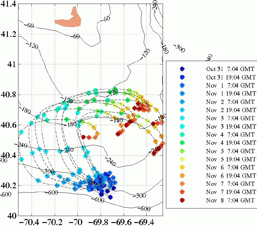
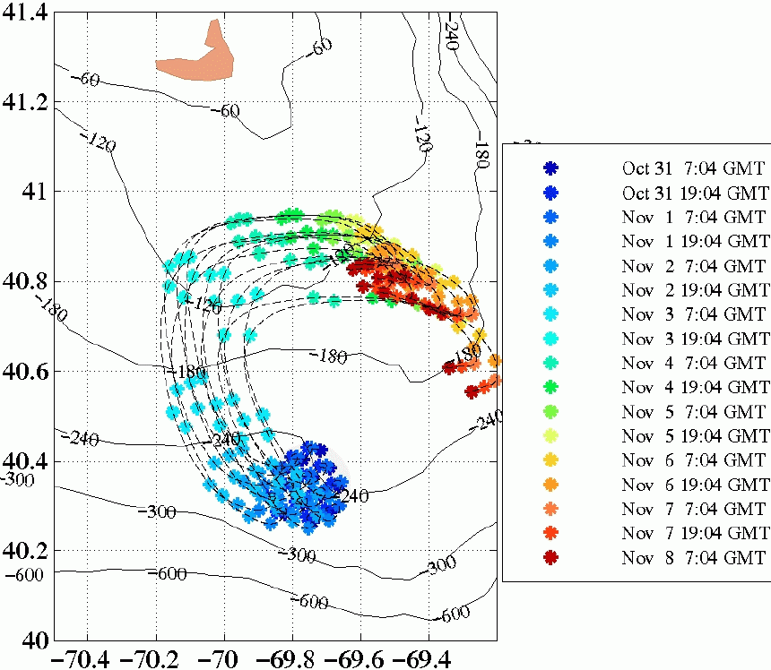
The figures below depicts the potential drift paths of floating debris for the period
31 October - 8 November. The gray circle indicates an area 10km in radius
from the presumed impact point of Egypt Air Flight 990. Particles located within
the gray circle at the time of impact (0700 GMT 31 October) are tracked for the
duration of the simulation period. The paths of these particles are plotted
for every model time step. 12 hour intervals are indicated by the asterisks.
Bottom contours are labeled in feet.
The left figure corresponds to an impact point located at 40.20N, 69.75W, while the
figure to the right corresponds to an impact point located at 40.35N, 69.75W.
The impact points have been estimated based on differing reports from the news media.
|
|
|
|
|
|
Potential paths of floating debris: 31 October - 8 November.
(Click on each image for larger size version)
Overall, the trajectories of the floating debris are dependent upon
the winds (strength, direction and pattern) and
the internal ocean dynamics (meandering shelfbreak front,
westward sluggish shelf currents and eddies, and Gulf Stream warm-core rings).
As shown above, the initial trajectories of the potential debris are influenced
by the location of the area of possible impact site with respect to an
oceanic front, the shelfbreak front.
The surface currents of the front are westward-southwestward,
meandering approximately along the path of the 300 foot isobath.
Beginning around Nov. 2, 1200 GMT,
the winds pick up in strength, towards the north,
becoming very strong on Nov. 3, 1200 GMT. During this period,
all simulated debris are moving rapidly primarily northward, turning
in the north-northeast direction,
and away from the shelfbreak frontal area.
Starting late on Nov. 3 up to Nov. 5 1200 GMT, the wind is
predicted to change direction
to the northeast and to weaken to strong-moderate winds.
All simulated debris are then predicted to deviate
east-northeast. On Nov. 6, 1200 GMT, the forecast winds
are to the southeast, and the debris start to move
south-southeast. Beginning on Nov. 7, the winds subside, turn to the
west and the debris follow the general slow shelf circulation to the west-southwest.
Northern impact point (40.35N, 69.75W; right image) -
This impact point is located further
from the influence of the shelfbreak front and the potential trajectories
respond primarily to the effects of wind forcing. Initially the
particles follow the main shelf circulation, moving a relatively short distance,
as calm winds conditions exist. Subsequently the winds increase and the
general pattern of the trajectories is mainly wind-driven, as was described for the
southern impact point.
Southern impact point (40.20N, 69.75W; left image) -
This impact point is slightly to the north of the shelfbreak front.
During the relatively calm wind period, from Oct 31 0700 GMT up to Nov. 2, the
motions of the floating debris depend on their position
with respect to the front.
The debris which are initially trapped in the front
are advected by the currents westward. However, the
debris which are to the north and south of the front
move sluggishly.
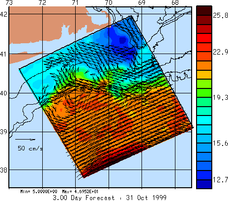
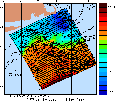
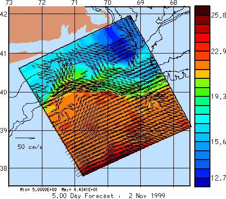
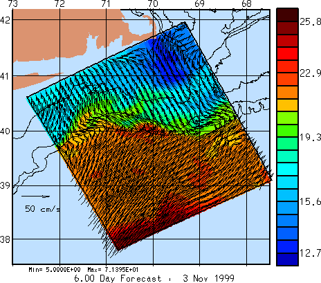
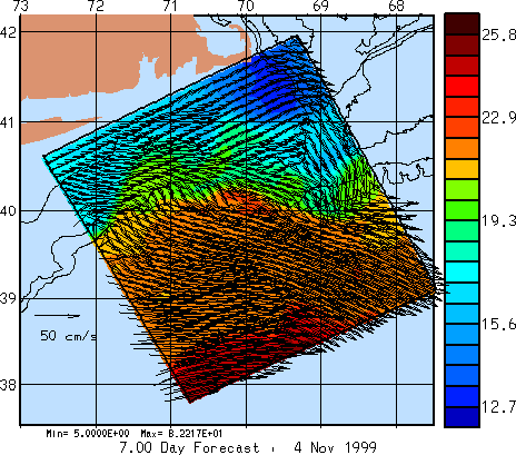
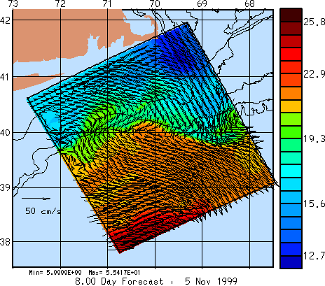
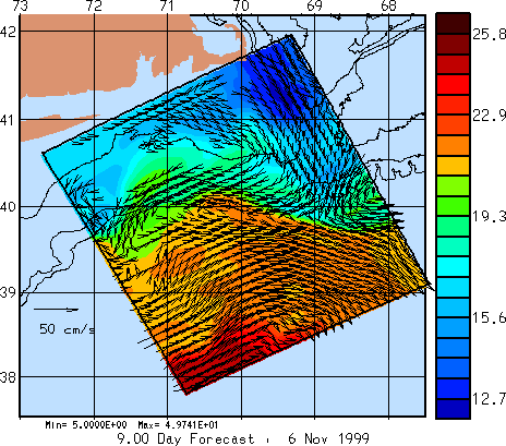
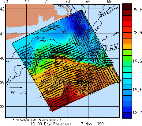
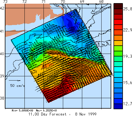
Temperature and Velocity Fields
The images below illustrate the 4-dimensional (space and time) simulation which
was utilized
to produce the potential floating debris paths shown above. Daily plots over
the duration of the forecast period are included. Each image shows
the temperature values at the 5 meter depth, overlaid with velocity vectors
at the same depth. The temperature scale is in Celsius and the velocity
scale arrow shown is 50 cm/s. Vectors are not
plotted if the velocity is below 5 cm/s. Note that the forecast period
begins on 2 November.
HOPS is a flexible, portable and generic system for inter-disciplinary nowcasting, forecasting and simulations. HOPS can rapidly be deployed to any region of the world ocean, including the coastal and deep oceans and across the shelfbreak with open, partially open or closed boundaries. Physical, and acoustical, real time and at sea forecasts have been carried out for more than fifteen years at numerous sites and coupled at sea biological forecasts were initiated in 1997. The present system is applicable in waters from 10m depth to several thousand meters and the heart of the system is a primitive equation physical dynamical model.