Back
Home
Setting-up Modeling Domains in HOPS
The setting-up of modeling domains with the HOPS software is accomplished
with three separate packages.
- GRIDS: a package to perform the basic definition functions.
- PE_mask: a package to define land masks for the domains.
- Cond_Topo: a MATLAB® package to conditions the domain
topography for improved Primitive Equation performance.
GRIDS
The GRIDS package enables the user to design a model domain for the Harvard
Ocean Prediction System (HOPS). In particular, the GRIDS package allows the
user to
- set-up and view the horizontal extent and resolution of a domain
- also define horizontally collocated, nested sub-domains
- define the vertical discretization
- extract topography from a gridded, evenly spaced database
- also extract topography between GRIDS files in nested
domain configurations.
- Condition the extracted topography for improved simulations
- clipping high & low values
- filtering
The GRIDS package, itself, is split-up into three programs:
- grids
- The workhorse program. It performs most of the
described operations.
| Input: |
netCDF
topography |
|
ASCII parameter input file |
 |
|
| Output: |
netCDF domain descriptor (GRIDS file) |
|
GMETA plot file |
|
|
Run Time: |
A few minutes |
- crs2fne
- A utility to help design collocated nested sub-domains.
| Input: |
GRIDS file |
|
|
|
ASCII parameter input file |
| Output: |
ASCII text |
|
|
| Run Time: |
|
- extract_grids
- A utility to align topographic & masking data
between one GRIDS file and a nested sub-domain GRIDS file.
| Input: |
2 GRIDS files |
|
Terminal input |
| Output: |
Overwrites one of the GRIDS files |
| Run Time: |
|
A more complete description of the GRIDS package in contained in the
GRIDS User's Guide. A gzipped PostScript version of the guide
(grids.ps.gz) is distributed with the GRIDS package.
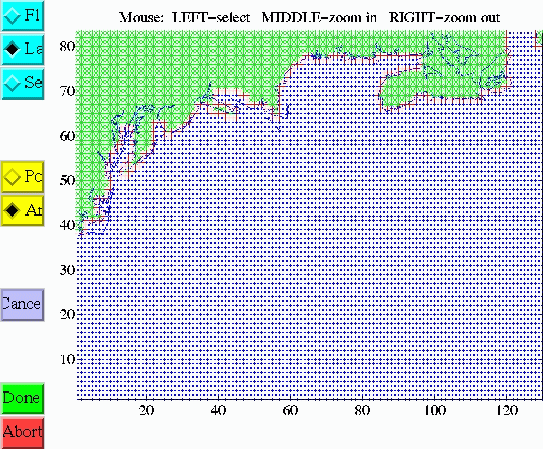
PE_mask
The program PE_MASK appends/modifies the Land/Sea mask data to an
existing GRIDS NetCDF file.
The Land/Sea data is first computed from the raw bathymetry contained
in the GRIDS NetCDF by specifying a transition isobath (said zero meters)
between Land and Sea. The user then modifies the mask to remove problem
spots (isolated ocean points, channels too narrow, etc).
The PE_MASK package is an interactive one. It includes several FORTRAN
routines and MATLAB M-files; both the FORTRAN and MATLAB routines
perform the same task. The MATLAB routines have the advantage that
the mask data can be determined graphically and it is faster and not
so tedious as the FORTRAN program. In addition, the MATLAB routines
have had several niceties added to reduce the work involved. These
features have not yet been ported to the FORTRAN version
If MATLAB is available, the MATLAB version of PE_mask is
highly recommended over the FORTRAN version.
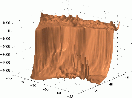
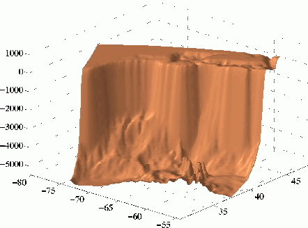
COND_TOPO
COND_TOPO is a series of MATLAB executable scripts designed to
reduce the slope of the topography for use in the HOPS Primitive Equation
model. These scripts are designed to modify only the topography in areas where
the slope exceeds a user-specified value according a user-specified measure.
| Raw Western North Atlantic
Topography |
Conditioned Western North Atlantic
Topography |
|
|
Currently, COND_TOPO exists only in MATLAB form. This is due to a couple
of reasons. The first is convenience. MATLAB was an easy environment to work
in while we were still developing this utility. The second reason is that,
on occasion, the conditioning can get really "lost". This means
that the user must carefully inspect the results of conditioning before
accepting them. MATLAB provides many tools for this.
A more complete description of COND_TOPO is provided in a couple of gzipped
PostScript files:
- cond_topo.ps.gz
- The beginnings of a users' guide for the COND_TOPO scripts.
- color_plate.ps.gz
- Color figures for cond_topo.ps.
HOPS Compatible Topography Datasets
(pub/HOPS)
| Directory |
Files |
Date
(MM/DD/YYYY) |
Size Compressed
(bytes) |
Size Uncompressed
(bytes) |
| |
|
|
|
|
| Atlas/ |
Readme.atlas |
11/18/1997 |
|
1631 |
| |
etopo5.nc.gz |
07/31/1995 |
11372838 |
18697556 |
| |
gom_topo.nc.gz |
11/13/1997 |
2779740 |
6372740 |