MSEAS Daily Prediction Summaries and Lagrangian Analyses
NSF-ALPHA Sea Experiment 2018 Home
NSF-ALPHA Project Home
Wednesday, August 15
Here are our predictions for tomorrow's planned release at 6-7am. They have been on the web and sent to Berkeley this morning.
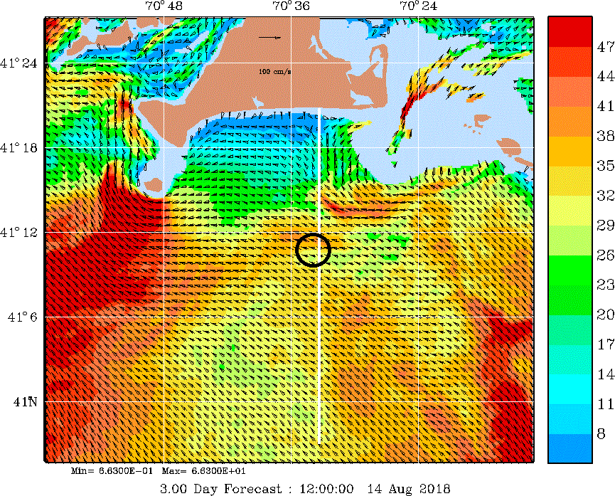
We forecast that there has been some upwelling due to the winds to the east/northeast (with some daily variations). This brings some of the subsurface fresher waters along MV's coast up, and pushes the light (warmer/fresher) near coastal surface waters offshore. Interestingly, we thus forecast that:
- The frontal features have become more 3D in some sense, with the front location and structure varying with depth.
- The front was still ventilated at the surface around 15-25 km from the coast this morning, in part from advection from the east. By noon or so tomorrow, this ventilation feature is forecast to advect further offshore to about 25-40km from the coastline, in joint response to the coastal upwelling process and to the continuing advection from the east. Of course, the exact locations will depend of the region south of MV (see our forecast horizontal maps) and on the accuracy of the wind forecasts too. The overall process should occur however.
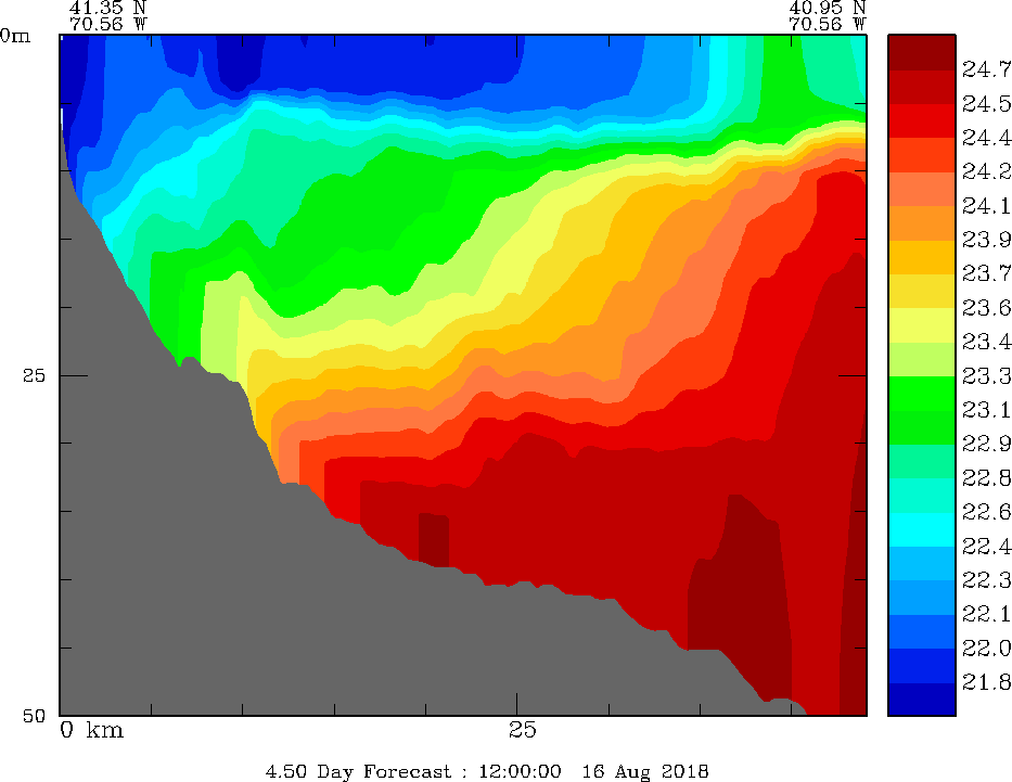
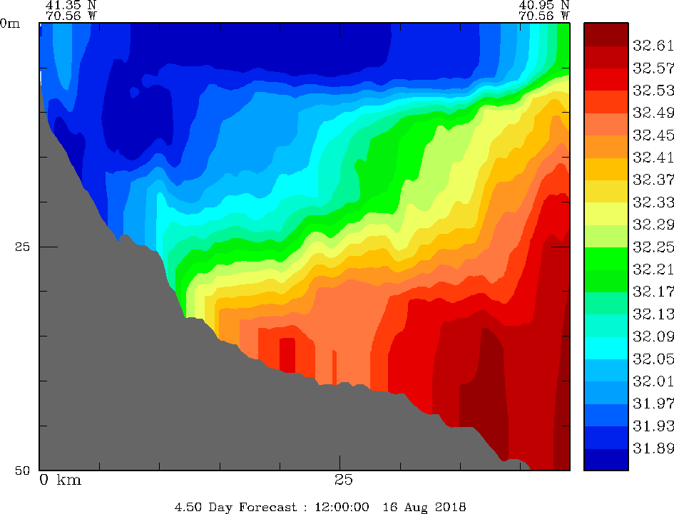
For tomorrow morning, here is our forecast for the MVCO section around 8am:
You can see the forecast changes here: http://mseas.mit.edu/Sea_exercises/NSF_ALPHA/2018/Sections/Maps/Aug15_Hz600m050_8am/sec1Z/index.html.
Around 8am tomorrow morning, our forecast for south of MV is:
- surface currents to the west-southwest
- 10m currents to be to the west.
Of course, this pattern will change rapidely with the tides. For the more detailed flows, see our webpage.
Drifter trajectories, 3D FTLEs, and flowmaps forecasts are also available on our site.
For the dye release, if I understood well where you released Wed morning, I think you can release at a similar location this Thursday. It depends if you want to target the 15m/lower salinities or the surface flow more. The former may mean just a bit more to the west/northwest, while the later a bit more to the east/southeast (so you have longer trajectories). With the upwelling, things may be interesting. Too bad we could not release drifters this afternoon and overnight, but it should still be interesting tomorrow.
Monday, August 13
We emailed with Tom and Irina several times today and posted one of our new forecasts for tomorrow on mseas. We have six forecasts uploaded on Berkeley.
For the possible tracking of the die for 6hr tomorrow, here are some 3D flow map restricted to my understanding of the possible region of interest. The release is at 15m and forecasts are given every hour: of course, the actual pathways will also depend on the die density. The fields are computed/prepared by Chinmay, Arkopal and Deepak, using PE forecasts from Pat/Pierre/Chris/Jade/Wael:
Also useful:
Here is another suggestion a bit more offshore and downstream. This location is still in the near-coast front, but a bit more within the core of it and not so close to the lower salinity edge (closer to the coast):
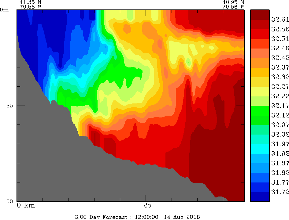
See also this cross-section, the proposed location/15m-depth/8am-time should be within the lower salinity pocket:
http://mseas.mit.edu/Sea_exercises/NSF_ALPHA/2018/Sections/Maps/Aug13_Hz600m041_5pm/sec1Z/csec_Ssec1Zoom_Hz600m041_001.gif
Of course, there are a lot of uncertainties. We have not had any deep in situ data in the region for 13 days.
Thursday, August 9
For the main experiment, we need to cover a larger area so as to really sample the basin of attraction of the LCS within the Muskeget channel and also on the other side of the LCS (south of the FTLE and OECS features). This was in Margaux's drawing - she emailed us - and in our selected regions (see above). In summary, to be closer to what I understood from our meeting, I recommend:
- A multiscale pattern where we have a higher density of drifters around the main attracting feature (and for shorter OECS time-scales) but keep 12 to 14 drifters for the rest to really capture the whole dynamic feature.
- Perhaps consider a bit wider OECS-based release for 6 to 8 drifters, to account for our forecasts of LCS uncertainties. This would illustrate the smaller and faster scale processes, but with uncertainties to be different from last year.
- Release one manikin with the drifters that cross the channel and another for the OECS drifters
- Account for the windage effects and wind-based LCS from Peter's and Shane in some of the drifter release plans (I could not see the info on my screen for this one but it was discussed and I thought we agreed).
I don't think the integrated plan above has been done before.
What we learned from the mutual information fields is that trajectories that cover the upstream and downstream of the features tend to be most informative about the FTLE field itself.
MSEAS Muskeget Channel Release recommendations (pdf)
Wednesday, August 8
We posted 9 different forecasts on Berkeley's website at 8:30am. They cover this period 12Z Aug 07 - 12Z Aug 10 and have varying wind mixing, "tidal" mixing and bottom stress. This is not an ensemble forecast proper, more some tests on model parameters.
We noticed that yesterday's weather forecast may have had the medium warm winds from the south (1.5 dyne/cm2 or 0.15 N/m2 wind stress) coming in a few hours late compared to their analyses today (updated wind estimates by NAM based on weather data). By Ekman transport, such southward winds lead to slow a mean surface transport towards the east-northeast for the drifters. Wind-driven ocean responses right along the coast due to the slightly higher water levels there are also a factor in increasing near coast currents and thus the drifter motions just along the coast (advected eastward).
Tuesday, August 7
- Forecasts of Ocean Physics and Lagrangian Analysis with Uncertainties
We have issued this morning our Aug 7 deterministic ocean and Lagrangian forecasting products and posted results on our webpage: http://mseas.mit.edu/Sea_exercises/NSF_ALPHA/2018/.
All files on the Berkeley server.
- Weather forecast for tomorrow (Aug 8): Partly couldy and very humid. No precipitation expected early, but rain and thunderstorms possible in the afternoon. SSW winds around 15 mph early in the day but falling to less than 10 mph by nightfall. Wave heights 2 ft in Nanutucket Sound, 3 ft south of the islands all day.
Monday, August 6
- Forecasts of Ocean Physics and Lagrangian Analysis with Uncertainties
We have posted our ocean and Lagrangian forecasting on our webpage: http://mseas.mit.edu/Sea_exercises/NSF_ALPHA/2018/.
We have created new interactive forecast visualization products, see the first table on the page. For example, for the ocean
http://mseas.mit.edu/Sea_exercises/NSF_ALPHA/2018/Physics/Leaflet/Maps/Aug06_8am/200m/. We also have similar products for LCS fields.
Pat has pushed our central forecast around 1pm to the Berkeley site. Ensemble forecasts will be pushed very soon. We had one of our computer blades miss-behaving, must be the heat wave.
Weather forecast
Today: Partly cloudy and warm. Wave heights 1 ft inside Nantucket sound; 2-3 ft south of islands. Very humid. Steady winds from SW, around 15mph. No precipitation expected.
Tomorrow: Partly cloudy and warm. Very humid. Steady winds from SW, again around 15mph. Wave heights 2 ft inside Nantucket sound; 4 ft south of the islands, building throughout the day. No precipitation expected.
- Optimized MI-based Drifter Release Around No Man's Land
Here is the proposed principled release of five drifters according to mutual information forecasts, and within the region recommended. The goal here is to maximize the mutual information among the candidate drifter trajectories and the FTLE field around No Man's Land island.
- Drifters are released every 15 minutes as suggested by Irina’s plans, in accord with the reachable locations (from one release to the next) at the nominal ship speed and within the boxed-area around No Man’s Land island.
- The target FTLE field is the forecast forward FTLE from 14Z to 20Z on Aug 07, 2018, around No Man’s Land island. The pdf are forecast by our MSEAS modeling system and ESSE ensemble scheme.
- A total of 5 drifter release locations/times are proposed, optimized using mutual information and a greedy algorithm. They account for the dynamic currents and fields.
The results are shown here. The suggested five drifter deployment locations and times are mentioned in the header of the first table. The most informative choice is to release the first drifter upstream of the island going through the channel, and the second downstream. It seems logical that such two trajectories provide the most information about the FTLE field around the Island, in accord with the FTLE and trajectory pdf forecasts. The last 3 optimized drifter locations are mostly downstream.
Some more info:
- We also provide the results of independently-optimized drifter release. The first two releases still indicate upstream and downstream as the most informative
- We also forecast:
- The total mutual information of the 20 drifter locations along the ring (not shown). This total mutual information content with the forward FTLE over 6hours (14:00Z to 20:00Z) is around 2.97.
- If we consider the first 10 drifter release locations of these 20 drifters, then the total mutual information is 1.4277.
- For the same verification region and with our 5 optimal drifter deployments obtained using our MI-based algorithm, we forecast a total mutual information of 2.2. There indicates that choosing the drifter deployment locations using MI can lead to efficiently informative trajectory data for the estimation of the forward FTLE field in the region.
Sunday, July 29 and Monday July 30
- Initial Survey Recommendations for Tue Jul 31, Wed Aug 1 and Thurs Aug 2, 2018:
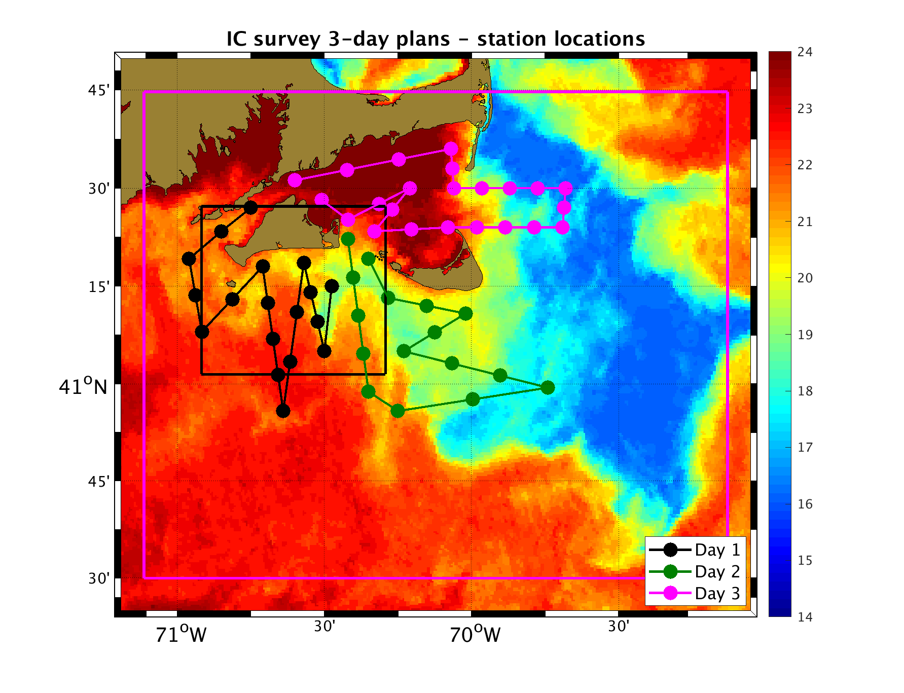
- In collaborations with Dr. Glen Gawarkiewicz, our recommendations for the CTD stations for the R/V Auk initialization survey are to sample the overall region around Martha's Vineyard and Nantucket, with higher-resolution around the meandering coastal front and with observations in the inflow currents, outflow areas, and strong tidal zones, so as to define the horizontal density gradients within the overall region. Ship ADCP data is also recommended if available.
The overall plan is to proceed at 16 knots or highest speed possible for most of the tracks (e.g. 20 knots):
- The first day (black stations) covers Vineyard Sound and the western coastal current region.
- The second day (dark green stations) covers the eastern coastal current region and the Nantucket shoals.
- The third day (magenta stations) covers Nantucket Sound, the Pollock Rip channel, and the inflowing Cape Cod coastal current.
- Our time estimate for all of this including the time for CTD stations is about: 11.48 hr for the first day, 11.63 hr for the second, and 11.24 hr for the third, assuming a speed of 16 kt. The exact time will depend on wave conditions, your exact speed, set-up time, etc.
- Station locations and tracks on SST
- Station locations (txt)