We now provide a 200m ocean simulation for higher-resolution in the islands region. That domain is nested (using implicit 2-way nesting) within an extended 600m resolution modeling domain, so as to better capture the source of the cold water and coastal current around the Nantucket Shoals. You can see plots of these domains and of the fields on the main page and sub-page. Some interesting tidbits and facts:
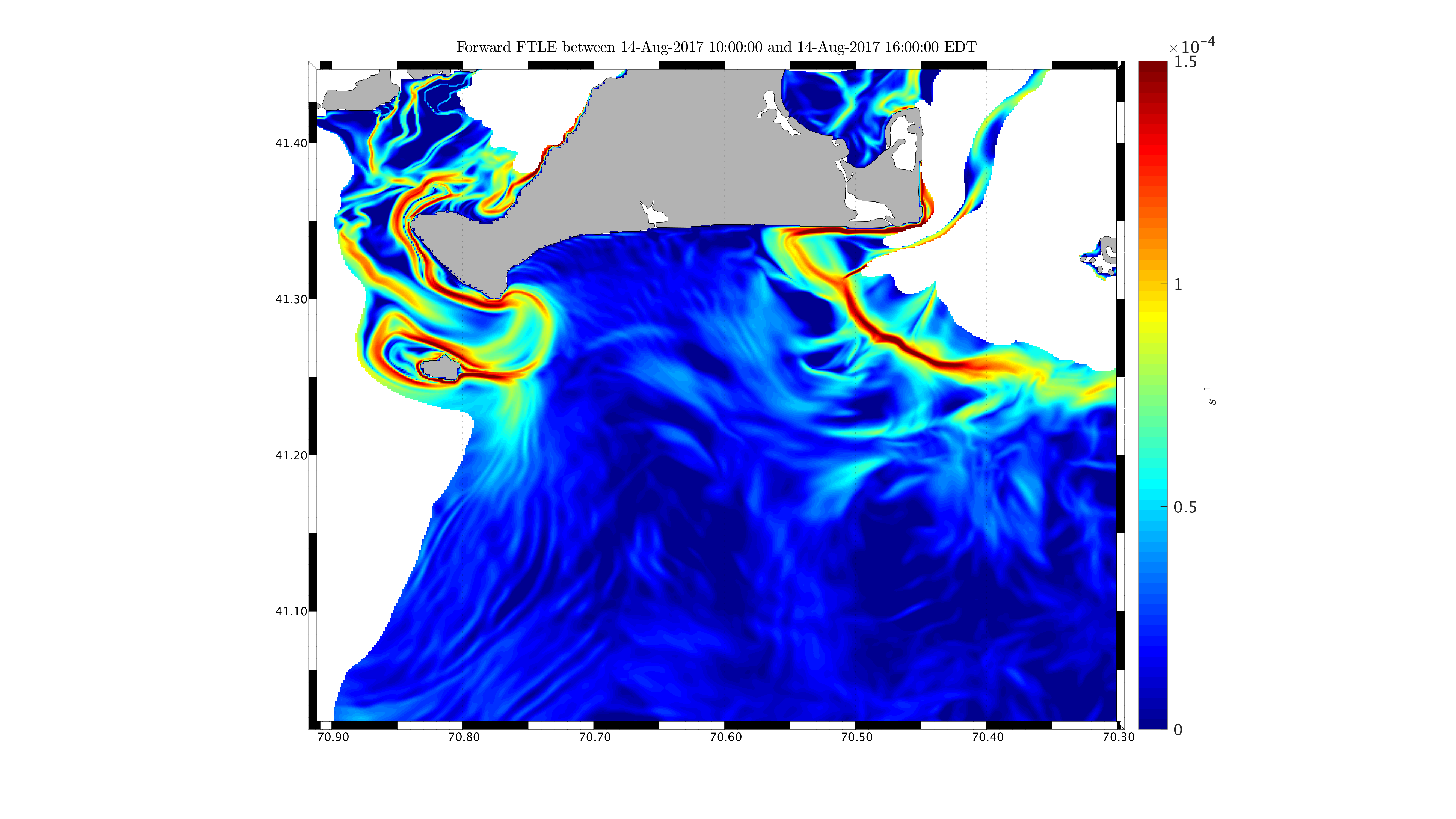
- We can see some nice Lee wave eddies on the edges of No Man’s Land as the tides reverse and as the flow goes above the steeper topography. Similar process at Gay Head but a single eddy there.
- In addition to the tidal recirculation eddy just west of Muskeget, you can also see tidally-driven and intermittent eddies on the sides of the Muskeget channel
- You can see the edge of the coastal current just south of MV and along MV (just south of 41.30), this might be a good feature for tomorrow’s short release, but there are others.
- The 200m provides some interesting features to target for the South Beach operations, but we are of course not sure of the timing of these features.
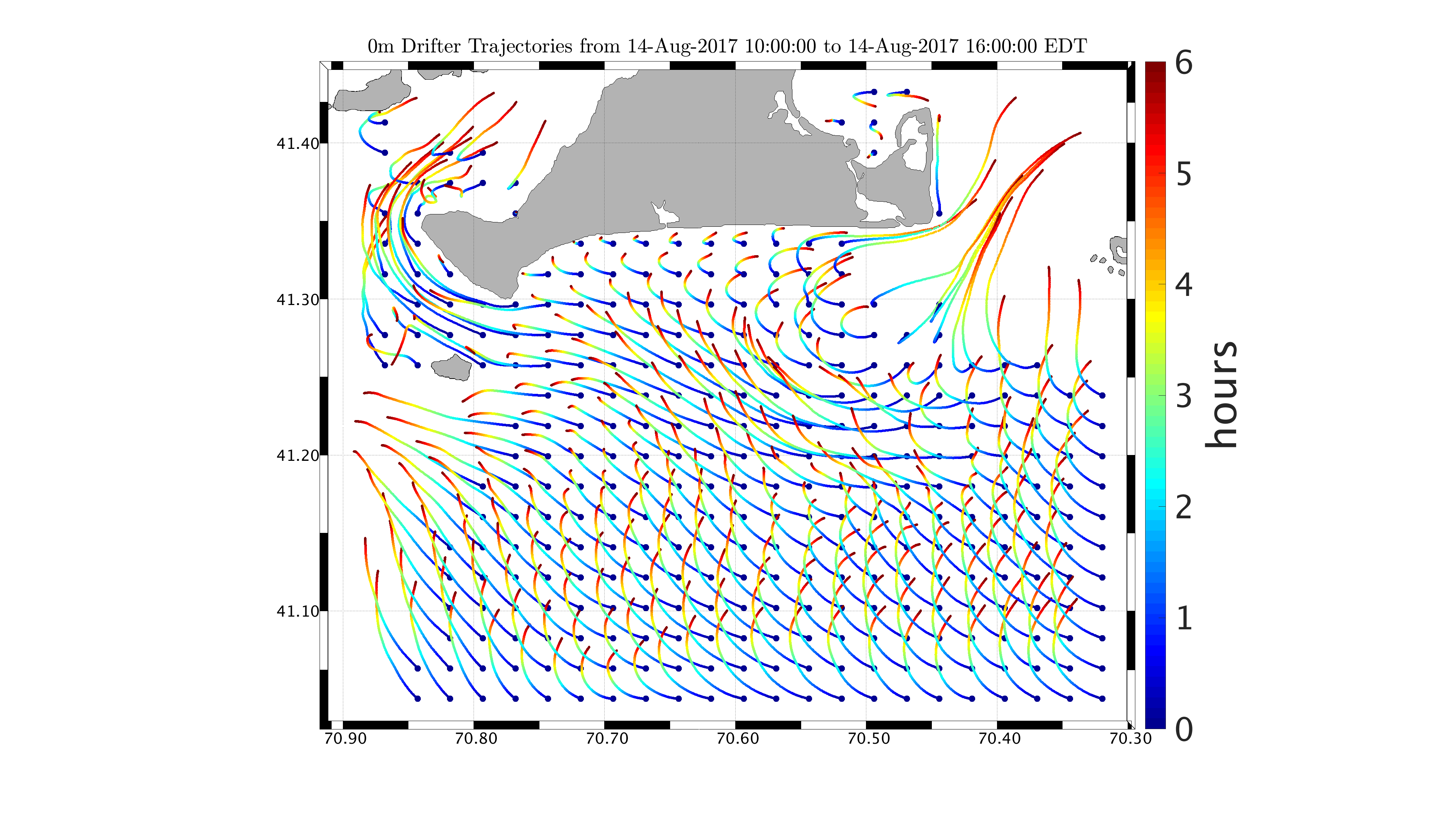
We now include drifter forecast predictions in our regular operations. For now, we only posted 0-m drifters, but we will also post 12m and 17m forecasts later on for Irina et al. This is a good complement to the LCS analysis forecast. Lagrangian information is provided every hour, from 8am to 8pm our time, for both 6 hour or 24 hour duration (see here).
- The 6 hour and 24 hour is to focus on the same day and next day pick-up.
- We provide LCS only every hour because we did not see nor expect too many changes in less than 1 hour. Our simulation is not fine enough to resolve such scales.
- (Martha's Vineyard Modeling domain: 200m resolution) http://transport.me.berkeley.edu/thredds/catalog/public/catalog.html?dataset=public/MIT_nsf_alpha200m_surf_vel_2017081200_2017081300_2017081500_01h.nc
- (Shelf Modeling domain: 200m resolution) http://transport.me.berkeley.edu/thredds/catalog/public/catalog.html? dataset=public/MIT_nsf_alpha600m_surf_vel_2017081200_2017081300_2017081500_01h.nc and here (to have 2 data sources just in case):
- (Martha's Vineyard Modeling domain: 200m resolution) http://mseas.mit.edu/Sea_exercises/NSF_ALPHA/2017/MSEAS/MIT_nsf_alpha200m_surf_vel_2017081200_2017081300_2017081500_01h.nc
- (Shelf Modeling domain: 600m resolution) http://mseas.mit.edu/Sea_exercises/NSF_ALPHA/2017/MSEAS/MIT_nsf_alpha600m_surf_vel_2017081200_2017081300_2017081500_01h.nc
- Today: Clear, winds from SW around 14 mph. Very humid. Significant wave height 1.6 ft. Strongest winds south of islands and in Muskeget channel area.
- Tomorrow: Clear, winds from ENE becoming SSW in the afternoon. Very humid. Sig. wave heights about 2 ft. Winds much lighter than today for all areas (north and south of islands). http://mseas.mit.edu/Sea_exercises/NSF_ALPHA/2017/NAM/20170813/index.html and http://www.tides4fishing.com/us/massachusetts/muskeget-island-north-side