

|
John Marshall (EAPS) and Pierre Lermusiaux (MechE) Massachusetts Institute of Technology
|
Amala Mahadevan
Woods Hole Oceanographic Institution
|
Amit Tandon (Physics)
UMass-Dartmouth
|
Ongoing MIT-MSEAS Research Additional MOPE Links Background References |


Ongoing MIT-MSEAS Research
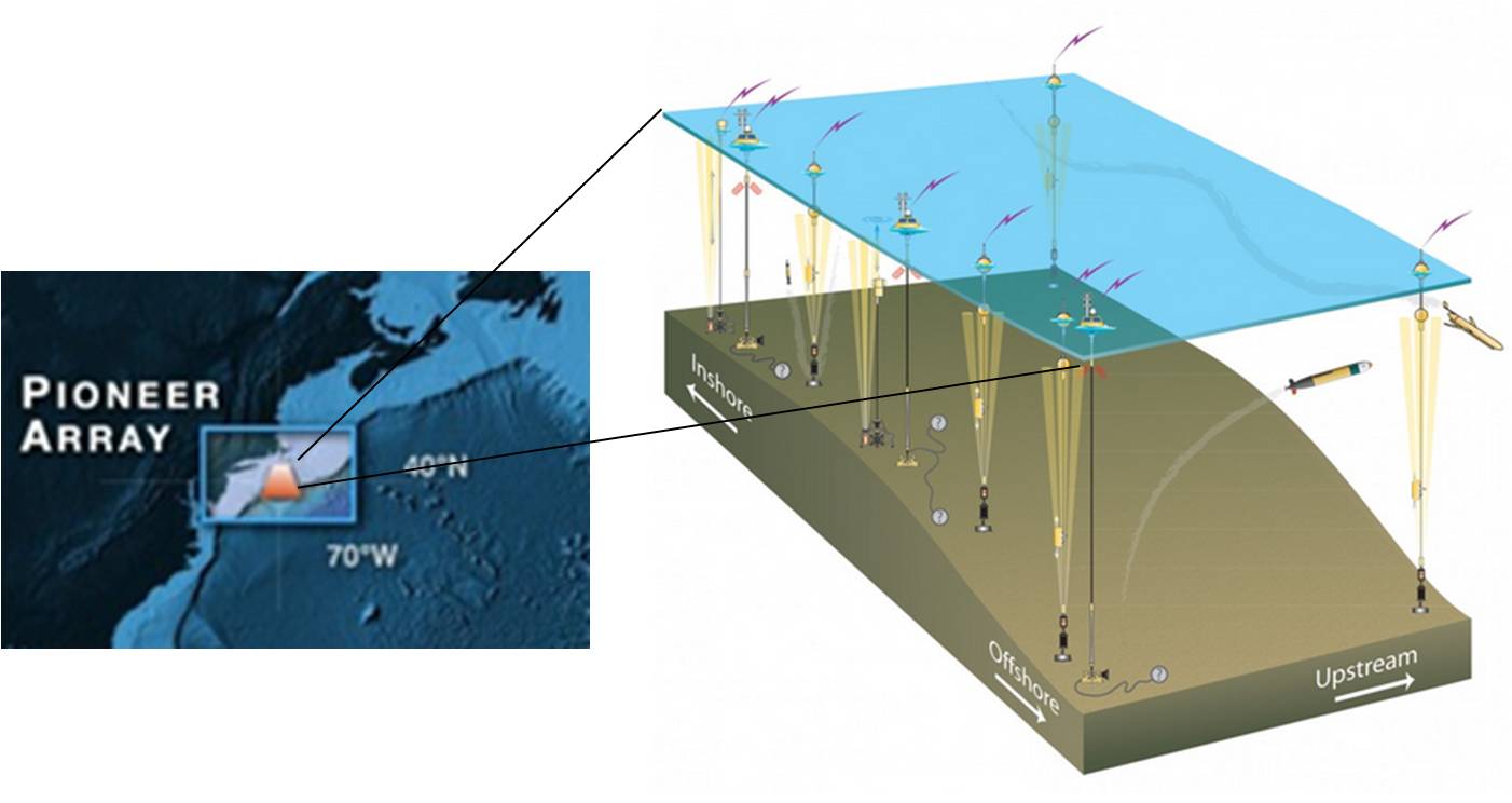
As part of the NSF Ocean Observatories Initiative (OOI), the oceanographic community is deploying a facility called the "Pioneer Array" tethered to the bottom of the ocean off the New England Coast. The array, when completed, will enable a flotilla of measurement devices of different types to provide a rich data stream of measurements of physical and biological processes in the vicinity of the shelf-break front (Fig. 1), a region of great importance to the oceanography and ecology of the coastal waters. Putting these measurements into perspective demands a multi-scale modeling approach that deploys multiple models across the scales of interest which talk to one-another and interface with the observations. Exploring a strategy to realize this computational/modeling infrastructure is our main goal. This is a pilot project to put in place the multiscale computational fluid dynamical modeling infrastructure required to make best use of the observations to be collected. This pilot project will seed an ocean modeling collaboration that will exploit opportunities provided by the Pioneer Array for longer term research and educational activities in the MIT, UMass and WHOI communities and around the region.
|
Fig. 1: The Pioneer Array is one of the world's first permanent sea-floor "nodes". The node will deliver power and high-speed network capabilities to the open ocean, enabling a flotilla of measurement devices of different types to provide a rich data stream, probing the ocean at unprecedented temporal resolution. |
- a workshop aimed at fostering collaborations between observers, engineers, technologists and computational fluid dynamicists around the OOI Pioneer Array (held 4-5 June 2012 at UMass-Dartmouth; click here for a link to the workshop) and
- a multi-scale ocean modeling pilot study designed to synthesize the observations and exploit the synthesis for science and engineering applications.
| Top of page |
Additional MOPE Links
- Pioneer Array science workshop
- Massachusetts Green High-Performance Computing Center (MGHPCC)
- MGHPCC 2012 Seed Fund Recipients Announced
- Ocean Observatories Initiative
- Pioneer Array
| Top of page |
Background
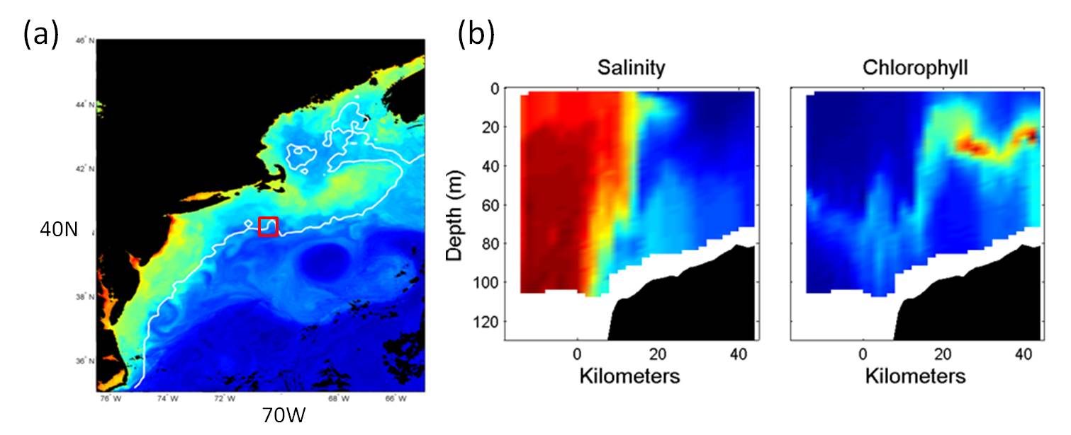
A main scientific objective of the Pioneer Array is to gather sufficient data to help determine the rate-controlling processes which govern the exchange of properties (both physical and biogeochemical) between the shelf and the open ocean, across the shelf-break front. This front separates the relatively cooler and fresher shelf water from the saltier and warmer offshore water, and is readily observed in sea-surface temperature and ocean color maps (Fig. 2). Its location is constrained in late fall and winter by the bottom topography, which transitions sharply from the continental shelf to slope (Fig. 3). The frontal dynamics involves multiple scales, from tides, internal tides and non-hydrostatic processes to ocean eddies and large-scale circulations. The cross-frontal exchange of shelf and slope waters is very important for applications ranging from the supply of nutrients to sustain the high biological productivity on the shelf, to the exchange of properties across the shelf, and the onshore transport of larval fish.
The pilot project entails significant computer modeling of both idealized and realistic scenarios, using Pioneer observations as constraints. The Pioneer Array will support sampling by stationary and mobile autonomous sensors. Sampling will be at discrete locations within a large region of ocean. Models play a central role in painting a complete picture of the regional dynamics. Ultimately we would like to develop and sustain a comprehensive, hierarchical suite of models that will facilitate a wide-array of complementary studies spanning (i) process modeling of microscale phenomena at the shelf-break, (ii) detailed, observationally constrained, reconstructions of the four-dimensional (three space dimensions and time) dynamics of the Pioneer array region and (iii) basin scale models for studying far-field interactions between local dynamics and ecology and the global ocean physical and biological environment. Such a hierarchy would provide a compelling research tool that could be employed in problems ranging from basic oceanographic and climate research to applied problems related to fisheries management, pollutant monitoring and national security. We will show the potential of such a hierarchy and provide demonstrable results for follow-on proposals to both federal and research foundation programs.
|
| Fig. 2. (a) Sea surface color as measured by satellite (averaged over 3 days in June). Ocean color provides a good quantitative estimate for the concentration of chlorophyll, hence of microscopic plants (phytoplankton) in the ocean. Red represents high values and blue represents low values. Black regions represent either land or clouds. The 200m isobath, at the edge of the continental shelf, is shown as a solid white line. The position of the Pioneer Array is marked by the red box. Courtesy of Dr. Heidi Sosik, WHOI. (b) Measurements of the boundary between the shelf and the open ocean (near 68 deg W, 40 deg N), with distance increasing shoreward. Left panel: salinity, where the lowest values (32.3) are in blue and the highest values (36.5), towards the open ocean are in deep red. Right panel: chlorophyll fluorescence (highest values are in red), which is indicative of the concentration of phytoplankton. Black represents locations below the sea floor. Courtesy of Dr. Kenneth Brink, WHOI. |
| Fig. 3: A schematic of the shelf-break front showing various associated physical processes. A more thorough understanding needs to take into account the along frontal variability in topography and forcing. Reproduced from Gawarkiewicz and Plueddemann, 2007. |

|
| Top of page |
References
- Gawarkiewicz, Glen, Frank Bahr, Robert C. Beardsley and Kenneth H. Brink (2001), Interaction of a slope eddy with the shelfbreak front in the Middle Atlantic Bight. Journal of Physical Oceanography, 31(9), 2783-2796.
- Gawarkiewicz, G., K. H. Brink, F. Bahr, R. C. Beardsley, M. Caruso, J. F. Lynch, and C.-S. Chiu (2004), A large-amplitude meander of the shelfbreak front during summer south of New England: Observations from the Shelfbreak PRIMER experiment , J. Geophys. Res., 109, C03006, doi:10.1029/2002JC001468.
- Lee, C. M., and K. H. Brink (2010), Observations of storm-induced mixing and Gulf Stream Ring incursion over the southern flank of Georges Bank: Winter and summer 1997, J. Geophys. Res., 115, C08008, doi:10.1029/2009JC005706.
- Lermusiaux, P.F.J. (1999). Data Assimilation via Error Subspace Statistical Estimation, Part II: Middle Atlantic Bight shelfbreak front simulations and ESSE validation. Monthly Weather Review, 127(7), 1408-1432..
- Lozier, S., M. Reed and G. Gawarkiewicz, (2002), Linear stability of shelfbreak fronts. Journal of Physical Oceanography, 32(3), 924-944.
- Mahadevan, A., A. Tandon and R. Ferrari, (2010), Rapid changes in mixed layer stratification driven by submesoscale instabilities and winds, J. Geophys. Res., 115, C03017, doi:10.1029/2008JC005203.
- Siedlecki, S. A., D. E. Archer, and A. Mahadevan (2011), Nutrient exchange and ventilation of benthic gases across the continental shelf break, J. Geophys. Res., 116, C06023, doi:10.1029/2010JC006365.
| Top of page |