Mid-Atlantic/New York Bight Region - January - February - March 2017
|
P.F.J. Lermusiaux, P.J. Haley, S. Jana, C. Mirabito, W. Ali, A. Gupta Massachusetts Institute of Technology Center for Ocean Engineering Mechanical Engineering Cambridge, Massachusetts
|
E. Dorfman, M. Goldsmith, A. Kofford, A. Laferriere, G. Shepard Raytheon BBN Technologies K. Heaney, J. Boyle OASIS, Inc. L. Freitag, A. Morozov Woods Hole Oceanographic Institution |
Real-time modeling Data sources |
 |
 |
POSYDON-POINT Project Main Page
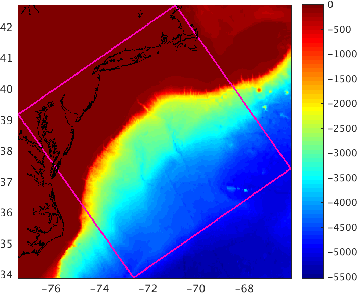
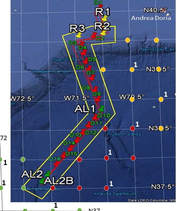
The POSYDON Sea Exercise 2017 occurs in the Middle Atlantic - New York Bight Region for January-February-March 2017. In collaboration with the POINT team, our objectives are to utilize the MIT MSEAS system to: (i) forecast the probability of high-resolution ocean fields using our ESSE methodology; (ii) transfer the corresponding distribution of the sound speed field to three-dimensional underwater sound propagation uncertainties; (iii) collect sufficient data to evaluate the accuracy of the Bayesian tomographic inversion and of its posterior estimates of range between transducers and sound velocity profiles (SVPs). We thank the POINT team members for their collaboration, the HYCOM team for their real-time ocean fields, and the NCEP HIRESW 5km, NCEP GFSp25, NAVGEM 0p5, and COAMPS NWATL NCEP teams for their real-time atmospheric flux forecasts.
This research is sponsored by DARPA.
Real-time MSEAS Ensemble Forecasting
- MSEAS ocean ensemble ESSE forecasts
Nowcast and Forecast Products
with dynamics and uncertainty descriptionsAnalyses and Forecasts Issued On Jan February March 30 31 1 2 3 4 5 6 7 8 9 10 11 12 13 22 23 24 25 26 27 28 1 2 3 4 5 6 Ocean Physics Horizontal Maps Central Forecast X X X X X X X X X X X X X X X X X X X X X X X X X X X X Mean and Uncertainty X X X X X X X X X X X X X X X X X X X X X X X X X X X X Operational Vertical Sections Central Forecast X X X X X X X X X X X X X X X X X X X X X X X X X X X X Mean and Uncertainty X X X X X X X X X X X X X X X X X X X X X X X X X X X X Reanalysis Products
with dynamics and uncertainty descriptionsReanalyses for February March 22 23 24 25 26 27 28 1 2 3 4 5 6 Ocean Physics Horizontal Maps Central Reanalysis X X X X X Mean and Uncertainty X X X X X Operational Vertical Sections Central Reanalysis X X X X X Mean and Uncertainty X X X X X - Four MSEAS-processed atmospheric forcing flux forecasts:
NCEP HIRESW 5km NCEP GFSp25 NAVGEM 0p5 COAMPS NWATL Jan/Feb/Mar 2017 S M T W T F S 22 23 24 25 26 27 28 29 30 31 1 2 3 4 5 6 7 8 9 10 11 12 13 14 15 16 17 18 19 20 21 22 23 24 25 26 27 28 1 2 3 4 5 6 7 8 9 10 11 Jan/Feb/Mar 2017 S M T W T F S 22 23 24 25 26 27 28 29 30 31 1 2 3 4 5 6 7 8 9 10 11 12 13 14 15 16 17 18 19 20 21 22 23 24 25 26 27 28 1 2 3 4 5 6 7 8 9 10 11 Jan/Feb/Mar 2017 S M T W T F S 22 23 24 25 26 27 28 29 30 31 1 2 3 4 5 6 7 8 9 10 11 12 13 14 15 16 17 18 19 20 21 22 23 24 25 26 27 28 1 2 3 4 5 6 7 8 9 10 11 Jan/Feb/Mar 2017 S M T W T F S 22 23 24 25 26 27 28 29 30 31 1 2 3 4 5 6 7 8 9 10 11 12 13 14 15 16 17 18 19 20 21 22 23 24 25 26 27 28 1 2 3 4 5 6 7 8 9 10 11 - Marine Weather Forecasts:
- SST Images
| Top of page |
Data sources
- Ocean synoptic
- The Global Temperature and Salinity Profile Programme (GTSPP)
- National Data Buoy Center Real-Time & historical data from moored buoy & C-MAN stations
- SST Images
- Ocean historical/climatological
- NOAA/NOS tidal elevation stations
- CO-OPS current station data (historical)
- The Global Temperature and Salinity Profile Programme (GTSPP)
- Data sets & products NOAA National Centers for Environmental Information
- World Ocean Database (WOD)
-
Northeast Fisheries Science Center Ecosystem Processes Division Oceanography Branch
NMFS. Includes data from CTDs, fish hauls, hull-mounted sensors, eMOLT
moorings, drifters, etc.
- Hydrographic Conditions of the Northeast Continental Shelf Northeast Fisheries Science Center Oceanography Branch
- Data/Mapping Interface Northeast Fisheries Science Center, Oceanography Branch
- Atmospheric forcing
- Weather Research and Forecasting (WRF) Model Real-Time Forecasts
- National Centers for Environmental Prediction (NCEP) products:
- High-Resolution Window (HIRESW) (5 km resolution):
- Global Forecast System Model: version 4 (GFS), at 0.5 degree resolution (GFSp5) and also at 0.25 degree resolution (GFSp25)
- The European Centre for Medium-Range Weather Forecasts (ECMWF) ERA Intrim (global Re-Analysis)
- ESSO - Indian National Centre for Ocean Information Services (TropFlux project):
- Coupled Ocean / Atmosphere Mesoscale Prediction System (COAMPS)
- Navy Global Environmental Model (NAVGEM) products:
| Top of page |


