

Precision Ocean Interrogation, Navigation, and Timing (POINT)
POSYDON – MIT - BBN
|
P.F.J. Lermusiaux, P.J. Haley, Jr., S. Jana, C. Mirabito, W. Ali Massachusetts Institute of Technology
|
Project Summary Ongoing MIT-MSEAS Research POSYDON-POINT-supported publications Additional POSYDON-POINT Links Background Information
|
|
|
| This research is sponsored by DARPA. | |||
Project Summary
The overal POSYDON program aims to develop a Global Positioning System (GPS) for underwater assets. The primary goals of our MIT effort are to:
- Employ and develop our regional ocean modeling, data assimilation and uncertainty quantification for the estimation of sound speed variability, coupled oceanographic-acoustic forecasting and inversion relevant to the POINT effort
- Apply our theory and schemes for optimal placement, path planning, and persistent ocean sampling with varied assets and acoustic source platforms
- Further quantify the ocean dynamics and variability of the regional areas of interest, utilizing our multi-resolution data-assimilative ocean modeling and process studies
This project is in collaboration with Raytheon BBN Technologies (E. Dorfman, M. Goldsmith, A. Kofford, A. Laferriere, G. Shepard), OASIS, Inc. (K. Heaney, J. Boyle) and Woods Hole Oceanographic Institution (L. Freitag, A. Morozov).
Background information is available below.
| Top of page |
Ongoing MIT-MSEAS Research
We plan to complete regional ocean modeling and forecasting for the Area of Interest (AOI). Our realistic data-assimilative modeling will involve real-time forecasting and data-driven simulations and analyses of the sound speed variability. To do so, we will build on our experiences, especially on large and collaborative research initiatives which were made possible by the Office of Naval Research. Our methods and software will be used and further developed for POINT. We will mainly employ our MIT-MSEAS hydrostatic PE code with a nonlinear free surface, based on second-order structured finite volumes (Haley and Lermusiaux, 2010).
For this project, we are also characterizing and forecasting the oceanographic variability and uncertainty. Our MIT-MSEAS PE model of the temporal and spatial evolution of physical features and circulations have been validated through extensive measurements, and analysis in many regions. However, due to the uncertain initial and boundary conditions, and sub-grid-scale parameters, the variability of the environmental propagating medium is uncertain. Just as we now utilize probabilities for rain or bad weather on a daily basis, the proposed underwater communication and global positioning system for deep ocean navigation can also utilize and benefit from such information. Real-time integrated oceanographic-acoustic predictions must account for and forecast these uncertainties and their effects on sound propagation and communications.
Real-time Sea Exercises (January and February 2017)
Real-time modeling products and data sources can be found on the 2017 Sea Exercises page.
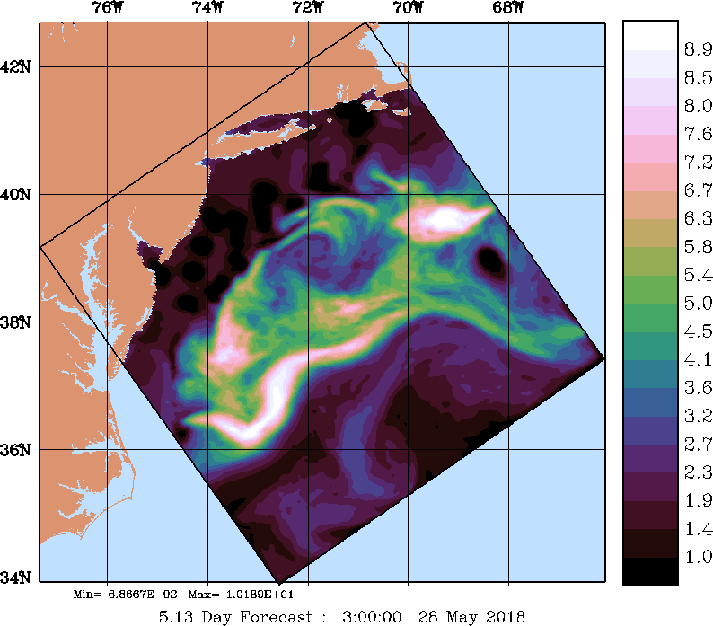
Engineering Test (May 2018)
Modeling products and data sources can be found on the Engineering Test page.
Real-time Sea Exercises (August 2018)
Real-time modeling products and data sources can be found on the 2018 Sea Exercises page.
Presentations and Meetings
Publications
POSYDON-POINT-supported Publications
Awards
| Top of page |
Additional POSYDON-POINT Links
- Positioning System for Deep Ocean Navigation (POSYDON) (DARPA program main page)
- GPS Doesn't Work Underwater (The Atlantic article)
- Improving Stealth Capabilities for Undersea Vehicles (Draper Labs article)
| Top of page |
Background Information
MIT forecasting of oceanographic and acoustic fields and uncertainties: For this "Precision Ocean Interrogation, Navigation, and Timing (POINT)" effort, we will utilize our MIT Multidisciplinary Simulation, Estimation, and Assimilation System (MSEAS) (Haley and Lermusiaux, 2010; https://mseas.mit.edu/software). The MSEAS software is used for fundamental research and for realistic simulations and predictions in varied regions of the world's ocean (Leslie et al, 2008; Onken et al, 2008; Haley et al, 2009; Gangopadhyay et al, 2011; Ramp et al, 2011), including monitoring (Lermusiaux et al, 2007), ecosystem prediction and environmental management (Besiktepe et al, 2003; Cossarini et al, 2009) and, importantly for the present project, real-time oceanographic-acoustic predictions and coupled ocean-acoustic data assimilation (e.g. Lermusiaux et al., 2002; Robinson and Lermusiaux, 2004; Xu et al, 2008; Lam et al, 2009; Duda et al, 2011; Colin et al, 2013).
| Top of page |